

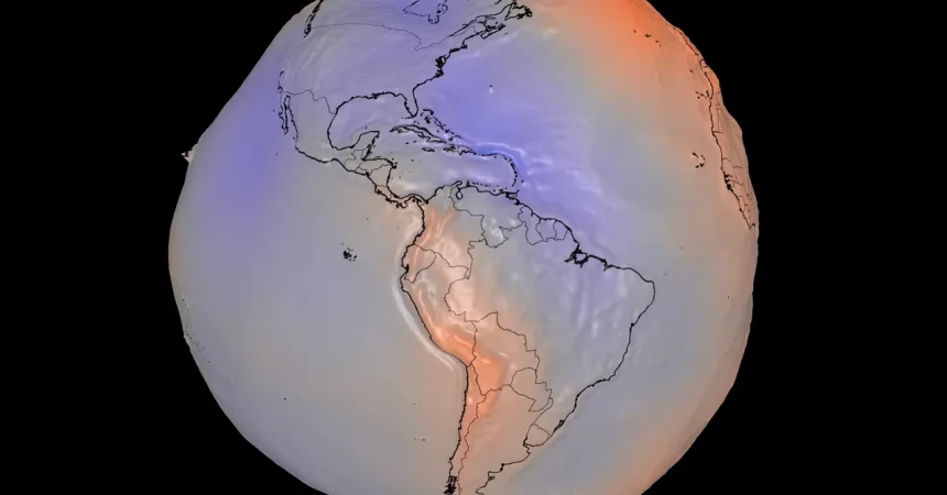
For generations, we have grown accustomed to the iconic image of Earth as a “Blue Marble”—a pristine, perfectly spherical jewel suspended in the dark void of space. However, NASA has recently released a new visualization that shatters this idealized perception. By mapping the Earth’s gravitational field, scientists have unveiled a “geoid” that looks less like a smooth orb and more like a lumpy, irregular potato. This model represents the hypothetical surface an ocean would take if it were sculpted solely by the planet’s gravity and rotation, devoid of wind or tides. While the Earth looks round to the naked eye, this visualization reveals that our planet’s mass is distributed unevenly, creating subtle bulges and depressions that fundamentally alter the gravitational pull in different corners of the globe.
To make the invisible world of gravity visible to the human eye, NASA’s team—led by science advisor Scott Luthcke and visualizer Mark SubbaRao—employed a significant mathematical exaggeration. They multiplied the actual variations in the gravitational field by a factor of 10,000. While this makes our planet look jarringly misshapen, it serves a crucial scientific purpose: it allows us to visualize data that would otherwise remain hidden from view. Built from 15 years of satellite observations and a staggering billion individual data points, this project is a masterpiece of precision. By offering an interactive 3D model alongside this visual data, NASA invites the public to move past the superficial beauty of space photography and engage with the complex, hidden mechanics that define the physical reality of our home.
Beyond the initial shock and curiosity this new map induces, measuring gravity is far from a mere academic exercise. NASA and the European Space Agency maintain constellations of satellites specifically designed to monitor the planet’s gravitational field, an endeavor that acts as a vital pulse-check for the environment. Because gravity is a direct function of mass, even small changes in the amount of solid or liquid weight on the Earth’s surface—such as the melting of a massive glacier—register as a detectable change in the local gravitational field. By keeping “gravity eyes” on the planet 24/7, scientists can essentially weigh the Earth from space, providing data that remains impossible to measure accurately through traditional sea-level monitoring alone.
The most sobering application of this data is found in the monitoring of the polar ice sheets. The GRACE mission (Gravity Recovery and Climate Experiment) has been recording the shrinking of our cryosphere with heartbreaking precision. Between 2002 and 2025, the data revealed that Antarctica has shed approximately 135 gigatons of ice per year, while Greenland has lost a staggering 264 gigatons annually. By monitoring these gravitational shifts, researchers are no longer just guessing about the rate of melt; they are calculating it with scientific certainty. This evidence is a cornerstone of modern climate research, helping experts predict how much higher the tides will rise and how quickly our global coastal communities will need to adapt to a changing shoreline.
Beyond the poles, these gravitational models are becoming essential tools for managing Earth’s most precious resource: water. The GRACE observations have provided a birds-eye view of groundwater depletion, highlighting long-term losses in the western United States and other arid regions. Furthermore, the technology is capable of identifying the subtle gravitational signature of soil moisture, which helps track the onset and severity of flash droughts. When the ground dries up, the mass of that region changes, and the satellites pick it up. As seen in recent climate data concerning drought-stricken regions in Spain and France, this satellite-derived information acts as a real-time indicator of environmental distress, revealing that soil moisture levels in those areas have hit record lows.
As climate change continues to intensify weather patterns and disrupt natural cycles, these satellite observations act as an early warning system for water-stressed societies around the world. By integrating this complex, “lumpy” gravitational data into the maps used by water managers and government planners, we are better equipped to prepare for the droughts and environmental shifts ahead. The shift from seeing Earth as a static, serene blue sphere to viewing it as a dynamic, shifting, and sometimes fragile mass is a necessary evolution in our understanding. NASA’s geoid isn’t just a scientific curiosity; it is a vital roadmap, reminding us that every change in the planet’s mass—from melting ice to depleting aquifers—is being quietly recorded by the very gravity that holds us to the ground.