

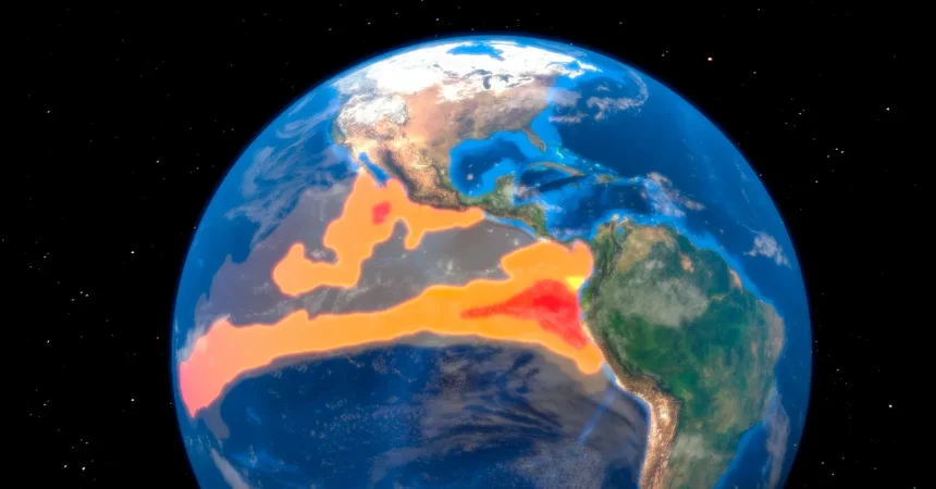
Think of the Pacific Ocean as a giant storage battery that holds heat for years at a time. Every few years, an unseen switch flips deep in the tropics, and that battery begins discharging its energy into the atmosphere. That is what people mean by El Niño. Named after the Christ child because it once appeared as a warm current near Peru around Christmas, the phenomenon is not just a warm patch of water. It is a shift in the way the ocean and atmosphere interact across thousands of miles. When the heat stored in the equatorial Pacific is released into the air, it changes where rain falls, where droughts take root, which places see bitter cold or unusual warmth, and how many hurricanes are likely to form in the Atlantic. El Niño occurs irregularly, every few years, but the event unfolding now is different. It has gained strength at an exceptional speed, and forecasters are increasingly concerned that it may reach an intensity never before recorded in human history. That can sound alarming, but it helps to remember that El Niño is not uniformly bad. A parched place like the American Southwest could finally see a substantial winter snowpack and steady rain, and a normally dangerous Atlantic hurricane season could be muted. The catch is that one region’s relief can become another region’s disaster. The “good” rain may turn into flooding, and a quieter hurricane season still cannot guarantee safety. For that reason, the real opportunity is not to panic or celebrate, but to prepare. To prepare properly, we need to understand what El Niño is, why this one might become a super El Niño, and where its effects are likely to be felt most sharply.
El Niño is not declared just because one part of the ocean feels warm on a weekend. There is a specific rectangle of water in the central-eastern tropical Pacific, known to meteorologists as NINO3.4, that serves as the primary diagnostic region. For an El Niño to be officially underway, the average sea surface temperature there must be at least 0.5 degrees Celsius—roughly 0.9 degrees Fahrenheit—above normal, and that warmth must persist for three overlapping three-month periods. That number may sound small, but in the Pacific Basin it is enormous, because the heat represented by even half a degree can be enough to alter weather patterns on a global scale. Different agencies have their own rules. Japan’s meteorological agency watches a slightly different stretch of ocean and uses its own thresholds. Australia’s bureau also requires atmospheric signs, not just warm water. The United States’ National Oceanic and Atmospheric Administration relies mainly on the ocean temperature threshold in NINO3.4. The mechanics of El Niño begin with the trade winds, steady winds that normally blow from east to west along the equator. Those winds push warm surface water toward Indonesia and the western Pacific, allowing cold, nutrient-rich water to rise from the deep ocean in the east. During El Niño, the trade winds weaken, and in strong cases they can even reverse. The warm water that was gathered in the west sloshes back toward South America, piling up along the eastern side of the Pacific. In major events like 1997 and 2015, sea levels there rose more than 18 centimeters, or about 7 inches, above average. That is a visible sign that the ocean itself is rearranging. Beneath the surface, a thick slab of warm water spreads across the eastern Pacific, and when that warmth eventually meets the air, it begins to rearrange the atmosphere’s weather machinery.
Once El Niño takes hold, its influence spreads outward like ripples from a stone dropped in a pond. It does not guarantee a specific outcome on any particular day; it tilts the odds. Think of it as loading dice. Some places become more likely to see heavy rain, others more likely to see drought, and still others more likely to see temperature extremes. In the United States, the most familiar pattern is the split between the Southwest and the Pacific Northwest. Southern California, Arizona, and the desert states tend to get more winter precipitation during El Niño, while the Pacific Northwest tends to turn drier. That is a welcome prospect after years of drought and dwindling reservoirs in the Colorado River Basin, but it is not automatically good. Rain that arrives all at once, or snow that melts too quickly in the spring, can cause flooding and mudslides. On the other side of the country, El Niño tends to make the Atlantic hurricane season calmer, because changing wind patterns over the Atlantic create more shear that tears storms apart before they can grow. Elsewhere, the effects can be much harsher. Indonesia and parts of southern Africa are at increased risk of drought, which can destroy crops and leave millions without clean water. Japan, parts of Australia, and Brazil often experience warmer winters. But El Niño does not act alone. Other natural climate patterns are always in the background, and weather on any given day is a messy, chaotic blend of many forces. El Niño simply becomes the loudest voice in the room when it is strong, leaning the probabilities in particular directions. The crucial lesson is that a “good” wet season can become too much of a good thing, and a mild hurricane season does not mean there will not be a devastating storm.
Scientists sometimes speak of a “super El Niño,” although no meteorological agency has made it an official category. In general, the term refers to an episode in which temperatures in the NINO3.4 region are at least 2 degrees Celsius above average. Only a handful of events in recent memory qualify: 1982–83, 1997–98, 2015–16, and 2023–24. Each one produced dramatic and sometimes heartbreaking consequences. The 1982–83 super El Niño dumped record-breaking snowfall on the Colorado River basin in the United States. That sounds like a gift, but when warm spring temperatures arrived and rain fell on top of the snow, the runoff gushed down the river at more than one and a half times its normal rate. Reservoirs upstream filled one after another, forcing emergency releases. Lake Mead rose so high that water poured over the Hoover Dam spillway for the first time in about forty years. What should have been a snowy blessing became a long, costly flood emergency. In 1997–98, Indonesia experienced its worst drought in half a century, with severe consequences for food, water, and wildfire risk. And the 2023–24 super El Niño contributed to the worst drought in more than a century across parts of southern Africa. Conditions became so extreme that roughly 61 million people required humanitarian assistance. These stories make an important point: a super El Niño is not a curiosity to be watched from a distance. It is a reminder that a relatively small change in ocean temperature can be amplified by weather systems into enormous human suffering. The warmer the ocean, the more energy there is to shove familiar weather patterns far outside their normal boundaries.
That is why forecasters are watching the current situation with a mixture of fascination and worry. According to NOAA, there is more than a 90 percent chance that this El Niño becomes “very strong” during the fall and winter. That alone would put it in rare company. But Berkeley Earth’s modeling, which accounts for the background influence of long-term global warming, suggests something even more shocking: the median temperature in the NINO3.4 region could reach 3.6 degrees Celsius above normal. To understand how extraordinary that is, compare it with the record-setting 2015–16 El Niño. This event would be roughly 0.8 degrees Celsius warmer than that. In context, the difference between the strongest and the fifth-strongest El Niño events over the past 150 years is only about 0.5 degrees Celsius. That means the projected leap from a strong historical event to this one is not a small step. It is a jump that would redraw the top of the charts. A warmer equatorial Pacific means more heat available to be thrown into the global atmosphere. It means that rainfall patterns, jet streams, and storm tracks are more likely to be pushed into extreme configurations. It does not guarantee that every forecasted impact will happen exactly on schedule, but it does raise the stakes. El Niño is a chain reaction, and when the initial push is this powerful, the reaction can be felt thousands of miles away through floods, droughts, heat waves, and storms. Meteorologists around the world are paying close attention because the cost of being unprepared is too high.
Where does that leave the rest of us? The temptation is to dismiss El Niño as a remote ocean phenomenon or to treat it as an unavoidable destiny. The truth is that it is a powerful natural feature of the climate, now unfolding against the background of human-caused warming, but it is still something we can anticipate and manage. A wetter winter in the Southwest could replenish reservoirs and reduce wildfire risk, but it could also cause floods and damage homes. A quieter Atlantic hurricane season is welcome, but one powerful storm can still be catastrophic. The practical task is preparation. Water managers need to decide whether to store water or release it before an expected flood. Farmers need to know which crops to plant and how to prepare for drought or excess rain. Emergency services need to stock supplies and position help where it might be needed. Families need to pay attention to forecasts, make plans, and understand the risks in their own community. None of us can stop the ocean from warming, and no single event can ever be blamed entirely on El Niño. But when scientists say this one could be among the strongest ever recorded, the responsible response is to listen, plan, and support the agencies and communities that will bear the impacts. The ocean is speaking through heat, and we would be wise to hear it. If we use what we know about El Niño, we can soften the blow and even benefit from the rain it brings. That is the whole point of anticipation: not to get through a super El Niño with our fingers crossed, but to stand ready with our eyes open.