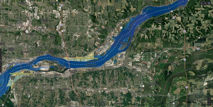
Scott County, Iowa, exemplifies proactive emergency preparedness in the face of escalating natural and man-made threats. Situated along the Mississippi River, the county confronts a diverse range of hazards, from commonplace floods and tornadoes to the potential for train derailments, earthquakes, and even radiation exposure from a nearby nuclear power plant. Recognizing the critical importance of timely and accurate information dissemination during emergencies, Scott County has pioneered a comprehensive approach to situational awareness, leveraging cutting-edge GIS technology to consolidate vital data and streamline response efforts.
The county’s innovative solution, known as the Situational Awareness Experience, represents a paradigm shift from traditional emergency management practices. By migrating from cumbersome paper maps and scattered data sources to a unified, dynamic mapping platform, Scott County has empowered its emergency responders with real-time access to critical information. This digital transformation has eliminated the need for tedious cross-referencing and time-consuming searches, enabling swift decision-making and efficient resource allocation during crises. The Situational Awareness Experience provides a comprehensive overview of the unfolding situation, displaying crucial details such as shelter locations, supply inventories, the location of vulnerable populations with specific medical needs, the progression of floodwaters or hazardous plumes, and real-time updates on evolving events.
The power of the Situational Awareness Experience lies not only in its ability to manage ongoing emergencies but also in its capacity to facilitate proactive planning and preparedness. The platform allows emergency managers to simulate various “what-if” scenarios, enabling them to anticipate potential challenges and pre-position resources accordingly. This predictive capability proves invaluable in addressing hypothetical situations, such as a hospital losing access to potable water, a power outage at an assisted living facility during extreme heat, or a shifting wind pattern carrying a hazardous plume towards a childcare center. By preemptively addressing these potential crises, Scott County enhances its resilience and minimizes the impact of unforeseen events.
The foundation of Scott County’s Situational Awareness Experience is Geographic Information Systems (GIS) technology, a sophisticated mapping and data management system that integrates diverse datasets onto a unified platform. This allows emergency responders to visualize critical information spatially, gaining a comprehensive understanding of the geographic context of the emergency. By correlating data points from various sources, the GIS platform reveals hidden patterns and relationships, providing valuable insights that inform decision-making. For instance, by overlaying population density data with flood risk maps, emergency managers can identify areas requiring immediate evacuation or prioritize resource allocation to the most vulnerable populations.
Scott County’s dedication to continuous improvement is evident in its iterative approach to emergency preparedness. With every real-world emergency or simulated exercise, the county meticulously analyzes lessons learned, identifying areas for enhancement and refining its data collection and dissemination strategies. This commitment to ongoing refinement ensures that the Situational Awareness Experience remains a dynamic and evolving tool, adapting to the ever-changing landscape of emergency management.
The increasing frequency and severity of extreme weather events and other emergencies underscore the critical need for effective preparedness strategies. In 2024 alone, the United States experienced 24 billion-dollar weather and climate-related disasters, marking the fifth consecutive year with 18 or more such events. This alarming trend highlights the urgent need for proactive measures to mitigate the impact of these increasingly common crises. Scott County’s proactive approach, exemplified by its investment in GIS technology and the development of the Situational Awareness Experience, serves as a model for other communities seeking to enhance their resilience in the face of evolving threats. Their approach highlights the critical role of technology in bolstering emergency preparedness, and in saving lives and protecting communities.
Scott County’s journey toward enhanced emergency preparedness has been marked by several key milestones. In 2019, facing the threat of record-breaking Mississippi River flooding, the county’s GIS analysts developed a custom flood prediction map that proved remarkably accurate. This experience demonstrated the power of GIS technology in forecasting and mitigating the impact of natural disasters. In 2020, when a devastating derecho struck the county, causing widespread power outages during a heatwave, the emergency management team leveraged GIS to identify vulnerable populations, such as those reliant on wheelchairs or oxygen tanks. By proactively locating these individuals and prioritizing their needs, the county effectively mitigated the potential for heat-related illnesses and fatalities. In early 2024, the county conducted a simulated exercise to prepare for a hypothetical attack on a nearby nuclear power plant. Utilizing the Situational Awareness Experience, emergency managers from various agencies and elected officials collaborated seamlessly, demonstrating the platform’s effectiveness in coordinating a complex, multi-agency response. These experiences demonstrate how Scott County has consistently integrated lessons learned into their practices, to improve their responses to emergencies.


